Climate changes and the local environment:
Mean global sea levels have risen by at least 17 cm (nearly 7 inches) in the twentieth century. Yet regional variations in ocean temperatures, prevailing winds, ocean currents, and the rise or fall of Earth's crust mean some areas have experienced, and will experience, greater sea level increases than others.
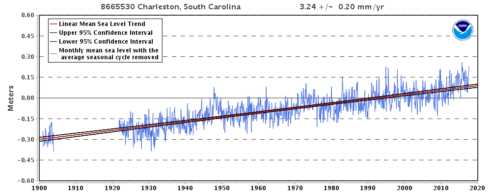
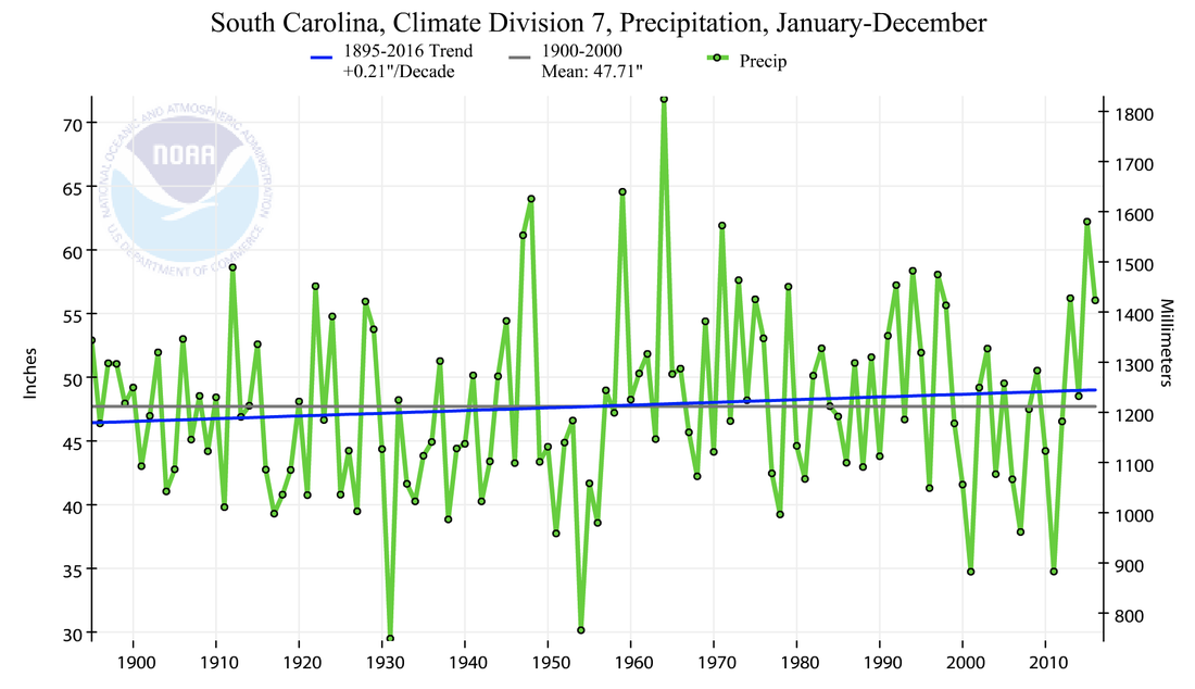
Over the past century, sea levels of Charleston, South Carolina have risen by nearly one foot (30 cm, or 12 inches), and have increased by an average of 3.2 mm per year. In recent decades, rising sea levels have sharply increased the risk of flooding in Charleston during periods of heavy rain. Average annual precipitation has increased only modestly in Charleston, but rainstorms have grown significantly more common.
As sea levels climbed, floodplains have also increased in size, meaning that more people and property each year became vulnerable to flooding. Nuisance flooding, or flooding from high tides without a storm, is four times more common in Charleston today than it was in 1950.
Meanwhile, hurricanes and tropical storms have grown more powerful and more capable of causing catastrophic flooding when they make landfall. From 1975-1989, roughly 20% of hurricane strengthened to category 4 or 5, with winds at or above 130 mph (209 km/h). From 1990-2004, the share that reached at least category 4 had increased to 25%. Hurricanes are fueled by warm, moist air rising from warm water. The warmer the water, the more fuel hurricanes can use.
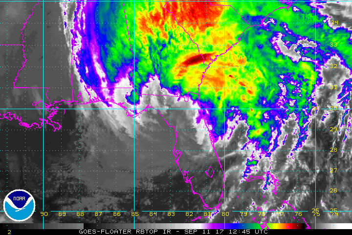
In recent years, sea surface temperatures have provided ample fuel for hurricanes that ultimately made landfall in South Carolina. Hurricane Matthew made landfall in 2016, and hurricane Irma reached Charleston as a tropical storm in 2017. Though much weakened from the historic intensity it reached in Caribbean, Irma brought a high tide of nearly 10 feet to Charleston, which sent flood waters cascading into the city.
Over the past century, sea levels of Charleston, South Carolina have risen by nearly one foot (30 cm, or 12 inches), and have increased by an average of 3.2 mm per year. In recent decades, rising sea levels have sharply increased the risk of flooding in Charleston during periods of heavy rain. Average annual precipitation has increased only modestly in Charleston, but rainstorms have grown significantly more common.
As sea levels climbed, floodplains have also increased in size, meaning that more people and property each year became vulnerable to flooding. Nuisance flooding, or flooding from high tides without a storm, is four times more common in Charleston today than it was in 1950.
Meanwhile, hurricanes and tropical storms have grown more powerful and more capable of causing catastrophic flooding when they make landfall. From 1975-1989, roughly 20% of hurricane strengthened to category 4 or 5, with winds at or above 130 mph (209 km/h). From 1990-2004, the share that reached at least category 4 had increased to 25%. Hurricanes are fueled by warm, moist air rising from warm water. The warmer the water, the more fuel hurricanes can use.
In recent years, sea surface temperatures have provided ample fuel for hurricanes that ultimately made landfall in South Carolina. Hurricane Matthew made landfall in 2016, and hurricane Irma reached Charleston as a tropical storm in 2017. Though much weakened from the historic intensity it reached in Caribbean, Irma brought a high tide of nearly 10 feet to Charleston, which sent flood waters cascading into the city.
How we know:
This information draws on a National Oceanic and Atmospheric Administration (NOAA) study that connects global warming and hurricanes, and a widely-cited 2006 study in the journal Science that reconstructs changes in the frequency of the most powerful tropical cyclones.
It also makes use of reliable, easy to use tools that are freely available online: the the NOAA Climate at a Glance app, and the NOAA Tides and Currents resource. The Climate at a Glance tool uses data collected at weather stations and stored in NOAA's U.S. Climate Divisions database. The Tides and Currents tool reconstructs sea level trends using measurements from U.S. and Global Stations, screening out regular seasonal fluctuations due to coastal ocean temperatures, salinities, winds, atmospheric pressures, and ocean currents.
It also makes use of reliable, easy to use tools that are freely available online: the the NOAA Climate at a Glance app, and the NOAA Tides and Currents resource. The Climate at a Glance tool uses data collected at weather stations and stored in NOAA's U.S. Climate Divisions database. The Tides and Currents tool reconstructs sea level trends using measurements from U.S. and Global Stations, screening out regular seasonal fluctuations due to coastal ocean temperatures, salinities, winds, atmospheric pressures, and ocean currents.
Human consequences:
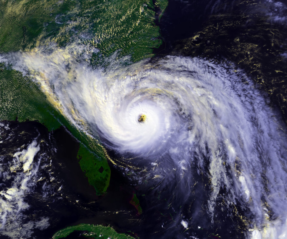
Tropical storms and hurricanes have crippled coastal cities like Charleston. In 1989, for example, hurricane Hugo swept ashore in South Carolina as a category 4 storm. It was fast-moving, and it therefore dropped only a relatively modest amount of rain. Yet its power resulted in a storm surge that reached 20 feet in some stretches of the South Carolina coast. Sustained winds in downtown Charleston reached 87 mph (140 km/h), but gusts exceeded 108 mph (174 km/h). The wind and water destroyed rows of beach houses, shattered docked boats, and collapsed part of the Ben Sawyer Bridge. The storm caused nearly $12 billion (2017 USD) in damage and directly or indirectly resulted in 35 deaths across South Carolina.
In 2017, Irma sent roughly 4 feet of ocean water spilling into downtown Charleston and caused the worst flooding in the city since Hugo made landfall. Since residents had not been ordered to evacuate, many were caught off guard by the flooding, and some needed rescuing. Irma was the costliest storm to reach Charleston since Hugo, and caused well over $1 billion in damage across South Carolina.
In 2017, Irma sent roughly 4 feet of ocean water spilling into downtown Charleston and caused the worst flooding in the city since Hugo made landfall. Since residents had not been ordered to evacuate, many were caught off guard by the flooding, and some needed rescuing. Irma was the costliest storm to reach Charleston since Hugo, and caused well over $1 billion in damage across South Carolina.
Less damaging but far more common nuisance floods have also imposed high costs on coastal communities across South Carolina, including Charleston. Tidal floods have inundated and therefore closed roads, and even modest floods have damaged vehicles exposed to the salty water. Heavy rain, meanwhile, has repeatedly caused flooding that drainage systems can only gradually alleviate. Since 1990, taxpayers in Charleston have spent over $238 million to repair drainage systems damaged by tidewater.
The worst flooding in Charleston has occurred in former marshes that once provided protection from rising waters but have now been filled in for development. Particularly at risk areas are actually sinking relative to the sea, since many were built on soil deposited by bulldozers that has grown more compact with time. Efforts have been made to stabilize beach houses and "renourish" beaches, which involves expanding beaches with sand from other sources. These ongoing initiatives have fortified at least some of the South Carolina coast in the face of rising seas.
The worst flooding in Charleston has occurred in former marshes that once provided protection from rising waters but have now been filled in for development. Particularly at risk areas are actually sinking relative to the sea, since many were built on soil deposited by bulldozers that has grown more compact with time. Efforts have been made to stabilize beach houses and "renourish" beaches, which involves expanding beaches with sand from other sources. These ongoing initiatives have fortified at least some of the South Carolina coast in the face of rising seas.
Further reading:
The Front Lines of Climate Change: Charleston’s Struggle. Climate Central
Your Post-Storm Update: Charleston Assesses Irma's Damage. The Post and Courier
Your Post-Storm Update: Charleston Assesses Irma's Damage. The Post and Courier
Article author: Kevin Berning, Georgetown University
Article editor: Dr. Dagomar Degroot, Georgetown University
Article editor: Dr. Dagomar Degroot, Georgetown University